Add a basemap
Use any map service as a basemap
CausewayOne Asset Management supports most types of online map service. By adding a basemap, you can connect to one of these map services and display its imagery!
You can add any number of basemaps to your company. However, please ensure you abide by the licensing of each map service you connect to. Some may restrict licensing for commercial use. Others may require the provider to be credited in a watermark, which is possible in CausewayOne Asset Management.
If necessary, admins can use permissions to restrict access to individual basemaps for different groups of users.
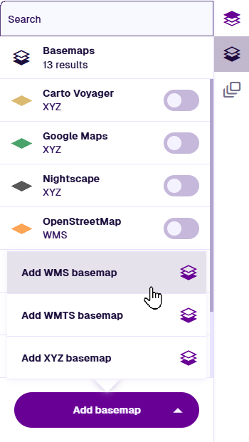
To begin, select Basemaps in the right toolbar, select Add basemap and choose one of the following.
📄️ WMS
Use a standard image map service
📄️ WMTS
Use a standard tiled map service
📄️ XYZ
Use a generic tiled map service
Coordinate systems
In CausewayOne Asset Management, all geometry is saved using the WGS84 Lat/Lng (EPSG:4326) coordinate system.
While you can add basemaps with different coordinate systems, note that item geometry will be automatically transformed (by us or the map service) while being displayed. As a result, item geometry may appear slightly misaligned with the basemap.